


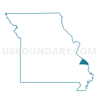
Longtown Voting District, Perry County, Missouri
About
Outline

Summary
| Unique Area Identifier | 609333 |
| Name | Longtown Voting District |
| County | Perry County |
| State | Missouri |
| Area (square miles) | 18.47 |
| Land Area (square miles) | 18.47 |
| Water Area (square miles) | 0.00 |
| % of Land Area | 100.00 |
| % of Water Area | 0.00 |
| Latitude of the Internal Point | 37.66840520 |
| Longtitude of the Internal Point | -89.73075050 |
Maps


Graphs
Select a template below for downloading or customizing gragh for Longtown Voting District, Perry County, Missouri


Neighbors
Neighoring Voting District (by Name) Neighboring Voting District on the Map
- Biehle Voting District, Perry County, MO
- Crosstown Voting District, Perry County, MO
- Farrar Voting District, Perry County, MO
- Frohna Voting District, Perry County, MO
- P-4 Voting District, Perry County, MO
- Uniontown Voting District, Perry County, MO
Top 10 Neighboring County Subdivision (by Population) Neighboring County Subdivision on the Map
- Central township, Perry County, MO (10,875)
- Cinque Hommes township, Perry County, MO (1,403)
- Brazeau township, Perry County, MO (1,100)
- Union township, Perry County, MO (1,062)
- Salem township, Perry County, MO (673)